Lake Effect Snow and Bitter Chills Grip Milwaukee This Friday
Winter’s Grip Tightens with Shoreline Snow
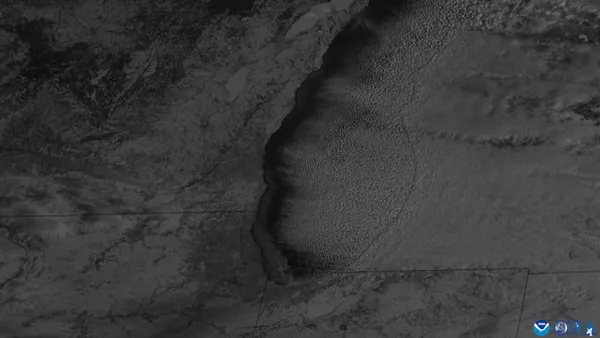
Milwaukee residents waking up this Friday, January 30, 2026, will find themselves in the thick of a persistent winter chill as a fresh wave of lake effect snow prepares to sweep across the city. After a week of fluctuating temperatures, the atmosphere has settled into a frigid pattern that will define the day's commute and outdoor activities. Meteorologists are closely monitoring a system that is expected to bring localized snow accumulation primarily to the southern lakeshore areas throughout the morning and into the early afternoon.
Morning Forecast: Snowfall and Single-Digit Chills
The morning hours will see the arrival of lake effect snow, with the highest impact expected from Milwaukee southward. While inland areas may only see scattered flurries, those closer to the water should prepare for a dry, powdery snow that could accumulate between 1 and 3 inches by midday. Temperatures will start in the low teens, but the real story is the wind chill. With moderate winds blowing out of the north at approximately 10 mph, it will feel much colder, often hovering near or below 0°F. Visibility may be reduced during periods of heavier snowfall, making the morning drive particularly hazardous along the I-794 and I-43 corridors.
Afternoon Outlook: Frigid Gusts and Overcast Skies
By the afternoon, the steady snowfall is expected to taper off into isolated showers, though the cloud cover will remain dense. The high temperature for today is projected to reach only 19°F, well below the seasonal average. Northerly winds will persist, with gusts reaching up to 20 mph at times, maintaining a biting cold that necessitates heavy winter gear. Humidity levels are expected to hover around 70%, contributing to the damp, bone-chilling feel of the air. Residents are advised to limit time outdoors, as the combination of sub-twenty-degree temperatures and steady winds increases the risk of frostbite on exposed skin.
Evening and Overnight: A Bitterly Cold Transition
As the sun sets, the lake effect activity will subside, giving way to a mostly cloudy evening. However, the reprieve from the snow will be short-lived, as a few stray flurries are forecasted to return after midnight. Temperatures will begin a steady descent, dropping to an overnight low of 12°F. Winds will remain consistent from the north, keeping the wind chill in the single digits throughout the night. Looking ahead to the weekend, a slight warming trend is anticipated, but for tonight, the focus remains on staying warm and clear of the icy shoreline gusts.
Travel and Safety Reminders
- Drive with Caution: Powdery snow on cold pavement can create slick spots; maintain extra following distance on bridge decks and ramps.
- Dress in Layers: Ensure you have a wind-resistant outer shell and moisture-wicking base layers to combat the negative wind chills.
- Watch the Shore: Lake effect snow is notoriously localized; conditions can change rapidly as you move toward or away from Lake Michigan.