Icy Transition: Snow Showers and Lake Effect Bands Grip Milwaukee Today
A Wintry Return to the Brew City
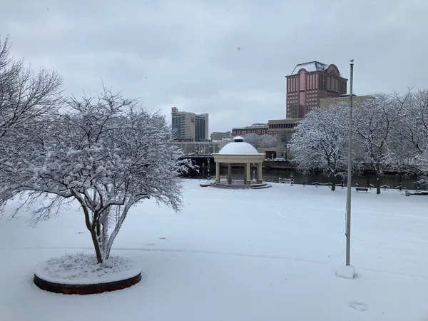
After a week that teased residents with unseasonable warmth, Milwaukee is facing a stark reminder of winter today, Saturday, February 28, 2026. A powerful cold front has swept through Southeastern Wisconsin, plunging temperatures back into the 20s and bringing a steady stream of snow showers to the region. Travelers and residents alike should prepare for slick conditions and a significant drop in mercury as the day progresses.
Morning and Afternoon: The Initial Surge
The day began with a freeze following Friday’s high of 61 degrees. Early morning commuters likely noticed light snowflakes fluttering as the cold air established its dominance. According to current meteorological reports, these light flurries are expected to strengthen significantly around noon as the main storm band flows directly over Milwaukee. During the peak of the afternoon, temperatures will struggle to reach a high of only 29 to 30 degrees Fahrenheit, more than ten degrees below the historical average for this date.
- Morning: Overcast skies with light snow flurries; temperatures holding in the low 20s.
- Afternoon: Intensifying snow showers starting around midday; peak high of 30°F.
- Winds: Northerly winds at 10 mph with occasional gusts reaching up to 22 mph, creating a wind chill factor that makes it feel like the mid-teens.
Evening and Overnight: Lake Effect Concerns
While the primary storm system is expected to begin tapering off by 9:00 p.m., the weather event is far from over. As winds shift to the northeast after sunset, lake effect snow is predicted to develop. This will primarily impact the I-43 corridor and coastal areas of Milwaukee County. Heavy localized bands could develop after midnight, dropping additional accumulation on already frozen surfaces. Overnight lows are expected to dip to 18 degrees, accompanied by steady 10 mph winds and significant cloud cover.
Accumulation and Safety Warnings
By the time the snow showers fully exit by midday Sunday, total accumulations are forecasted to range between 2 and 3 inches, though localized lake effect bands could push these totals higher in specific neighborhoods. Authorities are advising the following:
- Travel: Use extra caution on less-traveled side streets and the I-43 corridor, where snow may accumulate rapidly.
- Visibility: Periodic heavy bands may reduce visibility to less than half a mile during the afternoon hours.
- Apparel: Heavy winter gear is essential today as the wind chill will remain significantly below freezing through the evening.

Public invited to review preliminary Red Arrow Park redesign alternatives at City Hall Rotunda open house

Wisconsin approves state historic marker for Milwaukee’s former This Is It! LGBTQ bar building

Milwaukee officials outline changes to Brady list process, raising questions about notice and oversight